Showing posts with label mountaineering. Show all posts

Monday, April 28, 2014

Dickey Peak 11,145 ft
High point: Pahsimeroi Mountain Range, Idaho

Dickey Peak
Dickey Peak has been on my list for several years. It’s accessibility from Highway 93 and short, steep approach has been appealing. I also knew it had back country ski possibilities and was looking for Lost River options for Steve. An excellent weather window was forecast for Easter weekend, 2014, so we set our sights on Easter Sunday and headed out from Pocatello a little before 5 a.m.  Driving through Mackay, we immediately noticed the snow was coming off the south and western aspects of the Lost River peaks quickly. As we turned off the road to Arentson Gulch and were able to evaluate our west/northwest ridge approach, it was immediately obvious that there would be no “skinning up” for Steve. Scattered snow patches along our approach were going to mean a few wardrobe/gear changes along the way.

The Pashimeroi Mountains
We parked off the road at 7,459 feet, which we later learned would be a good spot. We started out about 8.15 a.m. The dry land section proceeded quickly and then we were in the lower level snowfields. We were able to make our way all the way through this section with the rare, knee to crotch-deep post hole.  The wind was light and the temperature comfortable as we moved from the continuous snow field to pick our way thought the scree field and snow patches of the steepest section to the upper ridge. 

At about 10,680 feet is where we chose crampons and axes to proceed to the summit. The snow was quite good but on the warm side in places. It could have been kick stepped for the most part, but it was faster not to. The wind stayed light and calm and it was deliciously silent, except for our movements. We were at the summit around 2.30 p.m., which is exceptionally slow (totally me there) and included gear changes and adjustments,. With no wind, perfect temps, and silence, it was so pleasant….nothing was threatening and other than knowing there would be warm(er) snow to deal with down low, no real reason to rush…it truly was a Sunday stroll.


Splattski!
The summit views were stunning, as they are in spring: crisp blue sky, bright white snow, and dark terrain features, punctuated with greens and browns as far as the eye could see. At the summit we looked at our descent options. There was a number of glissade options, but most of them involved a long traverse across Dickey’s base to return to the car. So we headed back toward our original glissade option that paralleled our ascent. As we set up to glissade our biggest concern was snow depth. If the snow was thin, we’d either have to plunge step down or go back to the ridge and take the screeway. Steve went first. Yea! It was perfect, so perfect in fact that I started sliding before I had my axe positioned.  Millisecond correction later and it was everything I (we) could do to not just slide all the way down the gully. What fun! 

We then hiked over rocks back to the lower snowfield and donned snowshoes for the lesser-fun section. The snow trolls had great fun placing random (post) holes for our pleasure and their entertainment. It wasn't horrible, but it might have made the top five. Back on dry land we headed over to the road to find it had turned into a river. Good thing we hadn't taken it farther up. Soon, we were back at the car, beer, chips, sandals and smiles.  On Easter Sunday, I am grateful to still be on mountain tops in exquisite weather! For more photos of this Idaho classic click here!    


4.6 mi (round trip)
3,832 ft (Garmin) gain
Total time: 10 hours (if you're not lollygagging you can knock this off much, much faster)
Weather: clear, below freezing (start) ~ 45 degrees (high) on mountain, no wind

Sunday, August 21, 2011

#112, North Twin Peak, #113 Red Cone Peak, Lost River Range, Idaho

North Twin Peak (c), Red Cone Peak (l)
When Dan put the note out that he was looking for hiking partners for the weekend of the 20th, I was initially excited, then a little concerned. I had just come off of a foiled Buck Mountain (Tetons) attempt and was really re-thinking my abilities. Buck Mt is third class, with some snow and an awkward, and draining, rock garden. I had gotten sick four times before reaching the saddle and then fell asleep at 10,400+ ft. Anyone who knows me knows that sleeping is something I never do in the mountains...I am too excited about being in the mountains to sleep. Apparently it just wasn't my day, but could I recover enough in barely a week to climb again?

I held out on a final decision until Thursday night when Dan put out a second note announcing that he, Zach and Tom Lopez, like "the" Tom Lopez, would be joining us to climb North Twin Peak, 11081 ft, in the Lost River Range (LRR) near Sunset Peak. Climbing with the IdahoSummits folk is a high priority on my list, but getting to climb with the man who wrote "the" book on Idaho climbing ...wow, priceless.

So with Steve's blessing to back out of our trip to City of Rocks with his friends, I did a little "wow I get to meet and climb with Tom" dance and then the furious packing, celiac-friendly carbo loading, and hydrating began.


View in the meadow.

I met the guys in Arco Saturday morning, and then off we went. We drove high into Elbow Canyon, started hiking along the road into a meadow, and then made an error...we kept climbing too far into the canyon and missed our right fork. We regrouped, checked maps, and thought through our location. We then began traversing, and steeply ascending, to achieve a spot somewhere near treeline edge to get a visual on our actual location.

As we contoured the slope and came out of the trees, we saw we were now in the right fork of Elbow Canyon, and not far off of our location estimate...but we definitely were not on the ridge we thought we were going to ascend in the first place.


Dan in the canyon heading toward the saddle.
North Twin (l), Red Cone Peak (r).

Regardless, the canyon was gorgeous, offering great views all around and the scree was easy traveling. We climbed up a shoot to get out of the canyon and made our way up to the saddle approach with only a small section of loose side-hilling to deal with.

The saddle was beautiful with flowers in bloom, bees buzzing, and butterflies flitting everywhere. We then picked our summit approach line from the saddle and began up the ridge to North Twin. Zach and Dan were ahead of me and Tom followed shortly behind us.


View from the saddle. Sunset Peak to the left, Sunrise, right.
 As we looked up, at a point approximately 200 ft below the summit, a Rocky Mountain Big Horn sheep "scout" appeared above us on a tower and peered down at the curious-looking multicolor "sheep" below.

With my amazing zoom I managed a pretty descent photo of him. Shortly after, we saw the rest of his herd, or harem, up on the summit. They checked us out for a bit, but as I slowly and quietly climbed up higher to reach Zach and Dan, they scattered.

Rocky Mountain Big Horn sheep "scout."

The three of us continued on and worked our way through some ledges. In short order, we reached the summit with Tom following shortly after.

From the summit, after the requisite video, splattskis, summit (and other) photos, and snack break, we made a tentative plan to descend to the saddle, climb up to Point 10,286 and take the "right" ridge back down. Back at the saddle, the plan was still a "go" and within minutes we were at the top of Point 10,286. Here we found a Rick Baugher summit film canister with his note that indicated he was at the summit 18 years ago. We also learned the peak's name was Red Cone Peak, a to-a-tee descripter. We signed his summit note and then surveyed our descent options.


Splattski, summit Red Cone Peak,
N. Twin in the background. Zach, Dan, Tom and Margo.

It appeared that after a steep pitch immediately off of the summit, to the east, that travelling would be easier via the Cabin Fork Canyon rather than the ridge as we originally planned. So off we went. When we arrived at the canyon scree, some of it was easier travelling for awhile but then it turned into "pay attention" scree. Regardless, we all made it back down into the forest, into the meadow, and back to the car without incident.

On the drive back out of Elbow Canyon we startled up a black bear that, quicker than we could grab phones or cameras to document it, hauled up a rock face. A reminder to folks in the LRRs...that there are bear out there...best enjoyed at distance.

After a long day of climbing in the LRR, the obvious option for dinner was Pickles Place in Arco. :-)  My GPS battery died, so here is the route I estimated off of the points I did capture...mapped it in Google Earth.

Route in relief.
It was a great day in the LLRs, made better with the company of Idaho Summit folk and the opportunity to meet the author of my Idaho climbing bible.  Thanks everyone for letting SummitGirl join you. Climb On!

Sunday, August 7, 2011

#111 Bald Mountain


One of the stellar views from hiking Baldy

Bald Mountain Trail
I must have had a pretty stupefied look on my face when she asked, “Margo, do you want to do a hike up on Baldy (i.e., Bald Mountain) with me in the morning”?  Not hours before I had just returned from my solo ascent of Grays Peak in the Pioneer Mountain Range of Idaho. Don’t get me wrong, I’m all up for mountains...the number in the title attests to that fact. And Grays was a respectable near 4,000 ft gain over 7 miles, so I am no slouch. But, frankly, I am of a certain age, where any summit is something to celebrate…just after a few days, not hours, of recovery. So two in a row...ahhhh, I don't know. “We don’t have to go to the top, we’ll just go to the gondola and ride down,” she added. “Well, how long will it take?” I asked. “About 2 hours,” she stated. Well, I don’t have any blisters, no cuts, no injuries from Grays…just really, really sore muscles. Okay, well this might help with recovery. “Ok, sure.”  So at 8:00 a.m. we are off to Baldy or Sun Valley Ski Area, as most folks know it, to head off on a 2.5 mile hike of less than 1.5K vertical. According to SummitPost,

"Bald Mountain...is home not only to North America's first ski resort, but also includes exciting hiking terrain along with unbelievable scenery."
I've been skiing here for years, but really hadn't considering hiking it before. So we are off on our beautiful, leisurely hike, and then something happens to me.  
Carol leads
When we reach the “decision” point, it’s only a mere 2.5 more miles to the top…3,000 ft vertical total. And I can’t help myself…how can I be this close and not go to the summit? “I think we should go to the summit,” I announce. Well alright then. And we continue on. Past wildflowers, ski towers, memorials to loved ones (really...it's a great idea), and beautiful healthy trees.  We climb gently ever higher and make the summit 10 minutes ahead of pace.   
An example view.


But then I notice...we're at the "ski" top...not the summit. "I need to keep going, I will only be a few minutes." Neither Carol nor I had brought anything other than water. After all, we were hiking for 2 hours...that's it. "I really need to get something to eat, and I've been to the top oodles of times," the former Sun Valley ski patroller says. "Absolutely." So we decide that she will go down and I will go up and we'll rendezvous for coffee at the lodge. 

Splattski
So I head up a fraction of a mile and a few feet more. From the top where there is an old lookout, I get views of yesterday's peaks from the west and can see my yesterday, Grays Peak, summit.  I photograph a few peaks of possible future interest and head down.

The Pioneers famous threesome
So this is the best part. If you hike up, you can ride down for free. First the chair lift and then the gondola. It was great. No stress on the knees...wonderful!! ...And it still counts as a peak. For now, I have been down numerous times, strapped to boards, and up the mountain once. It counts. Yeh, and it's all good.

No GPS, no stats. It was only supposed to be a little hike...What I do know is that turned out to be 5 miles, 3,000 ft, another bagged peak, and a fun time with one of my favorite friends. What an awesome weekend!!    
If you haven't considered it before, add hiking (or mountain biking) on Bald Mountain and a latte at the lodge to your bucket list.  
Chairlift Down
 
Gondola Down


Peak #110 Grays Peak, Solo #2


Grays Peak from 9200ish feet.
I have kept this peak at the top of my list for a solo outing and this was the weekend to go after it.  From SummitPost, "Grays Peak is a large hulking summit that stands out from the main crest of the Pioneer Mountains like a soar thumb. Although not as high nor rugged as its Pioneer counterparts, Grays Peak is still an attractive cone-shaped peak that is especially beautiful in winter."

I had checked into Grays in 2009 after my first solo. The folks on the Idaho Summits board recommended it for its proximity to the road (I drive a Nissan...not an off-road friendly vehicle), straightforward approach, and at class II/III, depending on conditions, was within my abilities, especially as a solo.
"Hal" at the trail head.

I decided to take the west ridge approach both ways, thinking it was easiest but noted that it would be relatively easy to bushwhack down to the Federal Gulch trail should I need to get off of the ridge. I took my GPS, with an estimated approach route, and unlike my first solo, a hard copy topo and a trip report.

I left Friday afternoon to stay with friends in Hailey and left at 6:45 a.m. to reach the trail head for a reasonably early start. According to my beta, it would be 5 miles and 4500 feet.
Heading to the high point at 9200ish ft.

When I reached the summit in almost exactly 4 hours, I was pretty stoked and in a little disbelief. After all, I got wrapped around a couple rock outcrops at lower elevations that ate up some time and I took a number of micro-breaks (stop for a moment until your breathing stops racing) when I was climbing above timberline.
View from 9200 ft
So, my ascent time seemed a little good to be true, but overall I felt pretty good, so I guess it was possible.

While on the summit I noticed weather building to the west and heading my way. Nothing too immediate, but sure enough to get a move on. So after the requisite snack break, 360 photos, video and Splattski, I was off.

Splattski!!
I made the decision because of the weather that staying on the ridge may not be a good idea. When I spotted the lower trail I bushwhacked a rib down toward it and followed the trail until it tied into the Federal Gulch trail.

Feetski!!
Once on the lower trail, I took my time to "smell the roses" as it were, or in my case, photograph butterflies. Where the trail came near the stream it was flooded so I spent some time trail- and vegetation-clump hoping to stay dry. The vegetation is some sections was SOOO tall that I couldn't see the trail in front of me, or under my feet, so I proceeded by "feet feel." A few stream crossings later, I was back at the car and then the shower started...perfect timing.

Bushwacking to the Federal Gulch Trail.
It took me 6 hours for the entire trip, including breaks. According to my GPS, total elevation was 3760 ft, and 7 miles long. Even though it wasn't as much elevation as I expected, I moved along quite well considering. I saw NO ONE, I heard nothing other than the sounds of nature. I left no trace. Thank you Sawtooth National Forest, Ketchum Ranger District for the non-motorized wilderness experience and for accurate signage. Thank you IdahoSummits Board, as always, for your knowledge and encouragement and friendship. Thank you family and friends for your support.
You can't buy more nature...only preserve, protect and enjoy it!
On may way out I stopped by the Hyndman Trail head just to, you know, look around...like at Cobb and other ideas.
:-)

My Route.


#86/109 Garns Mountain

Steve ascending the upper snowfield, Garns in view.

Garns Mountain, in the Big Hole Mountains, was Steve's suggestion for a peak near his place in Driggs Idaho. The plan was to ascend via South Horseshoe. This particular trail will take you right to the summit of Garns Mountain and out the opposite side of the Big Hole range should you chose to arrange a shuttle and through hike. Our plan was just out, up, and back. Usually in July you can get into most back country areas in the Teton Range, but this past winter and spring the range has been hammered again and again with snowfall. It will be well into August until some areas are easily accessible.
The Tetons from the summit of Garns

But today (7/9/2011) was a beautiful day in the Big Holes, and except for some snow patches, was passable, albeit rather wet and boggy in places. Correspondingly, every shady spot along the way was ripe with mosquitoes, so it kept us moving at a steady pace.

Looking over at the Tetons on the ascent.

We were passed by a number of dirt bikers and a couple mountain bikers on our ascent. At one point we chatted with a few taking a break. "I see you're doing this the old-fashioned way," one commented. "Where's your bike"? We laughed and admitted our old school method was by choice. We picked up some beta and moved on. They soon passed us, but snow turned them around not long after. Of course, our "old-fashioned way" laughs at snow. When we reached the summit, we overheard a cyclist that had come up from the opposite side comment that "I've been coming up here each year for 40 years and I've never seen snow up here this late."
Piney Peak from the summit.

We took a break, had a snack, and watched chipmunks beg from us while one even went so far as to taste Steve's pack strap until we shooed it off.

Me thinks pack straps are tasty treats!

We were really tired when we reached the car, and no wonder...15 miles round trip for 2500 vertical. Still a wonderful outing! More information about Garns Mountain can be found at SummitPost.

Sunday, May 1, 2011

# 85/107 Peak 10941 - Idaho Summits Spring Outing 2011

Margo and Cerro Ciento ridgeline (back)


The 2011 mountaineering season started out with #84, Camelback Mountain, a local peak outside of Pocatello. I had a rough winter 2010 physically. Seemed that everything broke down after the great mountain bike wreck of summer 2010. After a very difficult ascent of Camelback, I went back to the doctor and made another run at physical therapy. At the same time, I met this great guy, Steve, who got me out skate skiing about every weekend from the end of January through the begining of April. Between PT and Steve, the Idaho Summits Spring Outing came back on my radar. So I brought Steve along to meet a few of my climbing friends....

Peak 10941 was chosen after a lot of consternation over the initial choice of King Mountain in the Lost Rivers, a peak I had already done and was non-motivated to do again. Weather and snow stability conditions caused, thankfully, a change of location to this lovely little gem in the Boulder Mountains outside of Ketchum, Idaho. A bonus of the whole deal was that Idaho Summits Dan had rented his company's condo for us; so we left behind the camp gear and camp food and enjoyed comfy beds and good quality cuisine in Hailey. I was first to vote for Thai food because rice noodles (which are gluten free/Celiac friendly) carry more carbs then regular noodles...little known fact. So it was Pad Thai for dinner.

We enjoyed a leisurely 8:25 a.m. start at the trail head for a nine-person assault on the peak. Half the group planned to hike entirely and the other half would be descending on skis. Conditions were overcast when we started out but close to treeline a beautiful day burst into bloom. We ascended steadily without incident...just a few little weird steps here and there. At the high ridge traverse before the summit I followed Dan's decision to switch from snowshoes to crampons. Somehow I neglected to take a summit video or a SummitGirl photo but I did put a few
photos of the day together to music.

Of the nine, Alex, Dave, Dan and I climbed and descended the peak in snowshoes/crampons. John, Dylan and Steve skinned/cramponed up and skied down. Jacob booted up, crossed over and bagged Cerro Ciento before hiking and glissading down, and Nathan, bagged 10941, Cerro Ciento, and Easley Peak before skiing down. Skiers (who had met Nate on his descent) beat the climbers down by 20-30 minutes, and Jake pulled in about 5 minutes after the climbers.

Trip Stats
Mileage: 7.1 miles
Elevation Gain: 3800 ft
Time: 7:30 hours
Class 2+
Partners: Dan, Dave and Alex P., John and Dylan F., Steve, Jacob, Nathan.

Partner Trip Reports:
Dan Robbins:
Idaho Summits
John and Dylan Fagden:
Fagden's Adventures

Margo & Steve, 4/29/2011


Peak 10941 brings my unique peak total to 85. Multiple ascents of a few of these peaks bring my overall count to 97 and then I reach two entries in my spreadsheet of "numerous ascents," Carbonate Peak in Hailey and Bonneville Peak in Inkom. My guess for those is probably 5-6 each...so...instead of continuing to say I probably have about 100 peaks, I am conservatively taking my 107 total forward into Summer 2011. My next summit will start at number 108. So...wanna join me on a little hike?

Monday, October 19, 2009

No. 67, Deep Creek Peak

I wanted to go somewhere close to Pocatello, with a little less vertical than the 4,000+/trip I've done in recent weekends. Deep Creek Peak is the highpoint of the Deep Creek mountains in southeast Idaho that lie between Arbon and Rockland Valleys.

I planned on going solo but asked Margie, who's knee deep in sanding and staining her deck, to go. Putting added pressure on her, I mentioned that the peak was Maka (her dog) friendly. It wasn't until Saturday night that I found out that she had picked up the pace, finished her deck, and that I'd be having company.

Being overconfident in the peak's accessibility and straightforward route (per Dan's trip report), I opted not to download a map to the gps or print out a trip report, but I did bring Tom Lopez's book, with plans to use it for driving directions. Margie said she had been on the road and in that area before, so that was good enough for me. The route is 5 miles roundtrip, with a summit elevation of 8,748 ft and 2,000 vertical to get there, similar to our local Scout Mountain and Bonneville Peak, so we left Pocatello at 7:00 a.m. with expectations to be back by early afternoon.

After leaving I-86, we had the two-lane highway south through Arbon Valley to ourselves. Dawn was trying to break through the clouds when all the sudden, there he was, in the middle of our lane, a buck whose back was higher than the hood of her SUV. I didn't even have a chance to utter anything, I just looked over at Margie to see if she was seeing him, and her audible gasp answered my question. I had no more than a split second to look back at him to see if impact was inevitable. Margie was just processing her evasive action, when he decided he should move, quick. We passed him without getting a chance to swerve and within an inch of his rear. Margie could see his hair move in the swish of our passing.

Well it's a shame her heart rate monitor wasn't turned on, because I'm sure it would have belied her calm exterior. After some conversation about how much it would have sucked to fix her front end a second time, within months of the first time, we continued watching for his friends and looking for our turnoff.

Soon we were on Knox Canyon road, heading to the start of our ascent route. On the way we saw hunters with horses, hunters with atvs, and hunters with no plans to be more than 100 yards from their rigs for any reason (i.e., illegal road hunting, lovely). The biggest disappointment to me was to see how littered and dirty looking everything was within viewing distance of the road. I am convinced there are two classes of hunters. One class with, and one without. At least in this area, there seem to be a lot of hunters in that latter class.

Tom's book indicated that we were looking for an "intersection" of sorts on a "crest" (one way) or (traveling from the opposite direction)a "pass." And pass we did...the pass, that is (p.s. consistent terminology is really important, it's either a pass or a crest from either direction...yes I would love a climbing guide editing gig...email me). We understood we'd be doing a west approach on the peak, so we figured we needed to descend the road some more to reach said intersection. So without looking in the rear-view mirror, we kept going and traveled all the way to the north-south highway in the next (Rockland) valley, and the sign there told us, that we were on the Big Canyon road. Yep, just east-wested the entire range.

The error was obvious and we set the trip-o-meter to backtrack the 9 or so miles (per Tom' s book) where we suspected we should be. And, at about 9 miles, we were at the blue pickup hunter truck we saw on the way down. Must be here. We pulled in next to the truck.

We piled out, donned gear, and tried to make apparel decisions for the not-so-good-of-a-weather day we didn't expect but we were clearly going to get. Donning gear concluded with red shirts (hunter protection) all around...Maka included.

[I don't purposely try to hike or not hike during hunting season. It is something I don't really pay much attention to as in, I thought back at my the house, "Hum...there may be hunters out, hum, but i have no red or orange, hum...this is pretty much a ridge hike and I have a bright yellow backpack. Good enough." ]

So without looking in the rear-view mirror (i.e., behind us), we start off, 9:30, by crossing the road and immediately hiking up a steep hill, with no faint jeep trail noticeable (something I remember reading in a trip report somewhere). Then we're quickly in a very brushy section, sidehilling, with our first views of one of the multiple little peaks we'd go up and over before we would reach the summit. But something was bothering me. I kept looking ahead trying to see the ridge route that would be the majority of our climb and was seeing nothing other than more brush and heavy forest. Just not what I expected. I suggested we move from the sidehill to the top of the ridge above us and get a better look around. By then, we actually turned around and saw the peak we were supposed to be climbing, across the gully, the start visible less than 1/2 mile further up the road. So, down we went, and now with a 0.6-mi hill warm up under our boots and paws, we piled back in the car, moved it up the road, piled out and tried again.

It was at this point that the jeep trail was more than noticeable and as we continued, the route manifested as Dan describes in his trip report, "The hike starts out of a brushy, semi-forested ridge, that provides a challenge as it roller coasters up to the peak itself. Once on the mountain, the ridge becomes bare and a very easy terrain to hike." Spot on, Dan.

We discovered that Maka loves, among other things, tracking the trail, and she lead us the whole way. She was a little confused around a rock outcrop where numerous game trails exist. At that point we had to keep directing her upwards. Finally in the all too common blasting southeast Idaho winds, and significantly cooler temperatures than anticipated, we summited with plans to tag-off, take photos, and descend to a lunch spot that was out of the wind.

Even on this overcast day, there was at least 100 miles visibility. Bannock Peak (on the Fort Hall Indian Reservation) is a distinctive pyramidal shape, to the north, and this was my closest look at it from a mountaineering standpoint. Non-Native Americans are not allowed on the peak without permission from the Tribal Council, which I have learned through two attempts isn't (probably ever) granted. Mt. Harrison, and Cache and Independence Peaks were visible on the southwest. A dusting of snow was visible on Black Peak and Black Pine Peak to the south, which we'd summited a couple weeks before. The Lemhis were still snowcapped, Big Southern Butte had lost its snow, and the sun was shining on the Pioneers to the northwest.

The ascent was uneventful, just windy. On the descent, within about 20 minutes of the car, my left hiking pole collapsed sending me to the ground in a very hard side ankle roll. So i gimped a bit on the way out with new appreciation for "Margo tight," when adjusting the poles, not being tight enough. There were lots of shots taken by hunters but not at or near us. The only downside, if any, was the lost time caused by us not finding the trail head on first try (because I didn't download any coordinates/maps, lesson learned), and that sour melon poweraid is REALLLLY terrible.


It took us 5 minutes longer to complete the route than Dan and Zach. Including summit time and lunch...so we were quite pleased. We do agree with Dan that this is a good early season hike/conditioner once the road is open. So keep this in mind for next spring.
More photos here.

Saturday, October 17, 2009

Rainier 2000. Older trip report for a mountain that is still there...

Somewhere over the years in migrating to two newer computers, I lost files, important files, files I didn't want to lose. One of the older files I found was this trip report of my climb of Mt. Rainier. I corrected a couple words and deleted a sentence; otherwise, it is the original account written in 2000. A modified version with an assortment of the team's photos lived on the internet on ISU's Outdoor Program website for a long time, but it disappeared before I even thought to copy the photos. So all I have left are the photos pasted in the physical album and the few herein. My hope is to preserve the trip here, and maybe be able to track down and rescue the rest of the photos.


I lived in Bremerton, Washington, from 1983 to 1987. Jeremy was three, and I was primarily a stay-at-home mom. I was an aerobic instructor at the Bangor Military Base, and though I was interested in hiking, I never had any aspirations to climb anything. After all I was from Ohio, and it was already a big deal that I was living out west, let alone participating in any “extreme pursuits.” The first time I had an inkling to climb anything was on a hiking trip to upper Lena Lake. It was a long hike, and maxed out Jeremy, who had to be carried the last 20 minutes. The hike terminated at a small, beautiful alpine lake. Mt. Lena watched over us and appeared to be an easy scramble, albeit exposed. I remember commenting to my (ex-) husband that it would be interesting to climb to the top. He looked at me rather incredulously. So much for that thought.

Mount Rainier, at 14,410 ft, is the most heavily glaciated peak in the contiguous United States. Reaching the summit requires a vertical elevation gain of more than 9,000 ft over a distance of eight or more miles, depending on the route. In 1999, 10,919 people attempted to climb Mount Rainier; 5,255 summited. A large number of ascents are made by Pacific Northwest locals who attempt the 9,000-ft vertical climb from sea level, with varying degrees of success. Other attempts are made by Highpointers, as Rainier is Washington’s highest peak, and international climbers, training for something bigger. To these nonlocals, Rainier is just another peak. Nothing particularly special, just long and unpredictable. But to the “locals,” which I had been, Rainier is so much more. Bruce Barcott, in Measure of a Mountain, Beauty and Terror on Mount Rainier, states it best:

The local vernacular admits only one “Mountain,” and when Rainier rises we tell each other, “The Mountain is out.” Mount Rainier is at once the most public symbol of the Pacific Northwest and its most sacred private icon. A friend once disclosed that she says a prayer whenever she sees it. A stranger I met on its high southern flank told me, “you must love this mountain as much as I do,” but his reverent tone of voice told me I couldn’t. Lou Whittaker, who has climbed Rainier more than one hundred fifty times, told me about returning home from a Himalayan expedition and catching sight of the mountain, and feeling it snap his breath clean away. …We look at Rainier and regard the vastness of God; yet we look at it and claim it as our own.

In 1983, I fell in love at first sight with Rainier; I looked for him everyday; he had become “my” mountain.

I actually had an opportunity to attempt the summit with an outdoor program class at a local community college. I was in excellent physical condition at the time, but had no mountaineering experience. I felt out of my league, and without any friends interested in joining me, I lacked the confidence to go so far as to even sign up for the class. It would not be until 1995, after having summited, with Bob, my first “real” mountain in Idaho, that I expressed to him my interest in climbing this “peak” in Washington State. I think it blew him away when he read about the mountain.

In 1996, I suggested our vacation be to the Pacific Northwest. In all Bob’s travels, it was one area of the country he had not seen. We started in North Bend (off Snowqualmie Pass); traveled to downtown Seattle and explored the city, waterfront, and the infamous Pike’s Place Market; headed to the San Juan islands; stopped over in Victoria, B.C.; crossed over to the peninsula, visited friends in Bremerton; and “swung by” Rainier to climb to base camp and scout things out for a future summit attempt.

Having spent a week at sea level, the climb to Camp Muir, at 10,000 ft, became difficult for me around 9,000 ft. I got a headache, a bad one. When we reached camp, outside of using the rest room, I never moved from my seat on a rock until it was time to descend. I felt better as I made my way down, but also made a mental note to make a summit attempt directly from the higher altitude of Idaho, and save the sea-level sightseeing for later.

In 2000, and less than one week after a successful Mt. Moran summit in Wyoming, Bob and I were on our way to Washington to attempt Rainier with an ISU common adventure group. There were 12 people signed up for the trip, and one leader. Not a good ratio, and earlier that summer I had been advised by friends to consider pulling out of the trip and trying it another year, with a smaller group. I was convinced and tried to change Bob’s mind. But he was very practical about it all. We would go with the group, and if we were not comfortable with the situation then we would break away from the group and attempt the summit together or retreat, whatever was prudent.

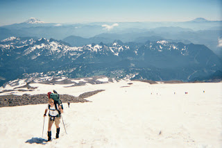
We arrived at Paradise Visitor Center/ranger station, on August 7th, and I was sent ahead (because I am slow and I knew where I was going) while Bob waited for ISU’s van. They arrived an hour late, and after a second hour of preparation, Bob and the group headed up behind me. It was beautiful weather, sunny and warm. Bob had left the main group and by mid-afternoon caught up with me, and we climbed the last 1,000 ft together. We set up our camp and by late afternoon everyone else had arrived and set up camp at Muir, where up to 110 people may stay per night

At this point two of the women decided not to make the summit attempt the next morning. One woman had recently had knee surgery and had only intended to get to Muir. Another woman had tried before, gotten sick, and turned her entire group around (it is standard practice for an entire rope team to turn around if one member gets sick). She didn’t want to be responsible for turning another group around, and we were appreciative of her decision.

It was time to group into teams. We wanted to be on a strong team. I felt I could keep myself going, but didn’t know if I could handle being turned around by someone weaker. Fortunately, Bob arranged for us to be on a rope team with Todd, a climber and guide, who drove out from Colorado for this trip. Todd would lead the two of us, and we would be the second of the three teams.

I had read a trail report in the shelter, which I assumed everyone else had seen, that directed climbers to start earlier than normal and be back at camp by 10:00 a.m., because the long period of warm weather had made rockfall/icefall danger extremely high. Therefore, I was voting to leave camp by 10:00 p.m. However, everyone else wanted to wake up at midnight (the standard time) to begin the hike up. So, having been out voted, midnight, August 8th, came and went and it was 1:45 a.m. when our three rope teams joined several other teams for the climb.

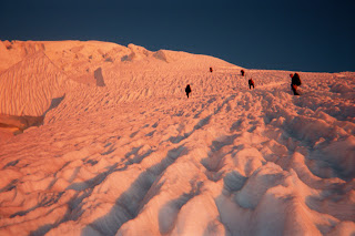
Crampons on and ice axes in hands we made our way over and around small crevasses, a 200-ft section of bare rock, and then an aluminum ladder “bridge” that crossed a narrow, but deep (we would see later) crevasse. We jumped over several other crevasses, still in the dark, as we headed toward the Ingraham Direct route. We passed high camp and its sleeping occupants, and we saw an absolutely beautiful and unobstructed view of sunrise on the earth’s east horizon.

We had originally planned to ascend the Disappointment Cleaver route, the most popular route on the mountain, but warm weather, rock and icefall, and detours around crevasses made it a less appealing choice. The Ingraham Direct is a Grade I/II route (strenuous, rock and ice fall, 35 to 40 degree snow and ice slopes, altitude) and had been the most traveled route to the summit in past weeks. A clearly marked, well-defined boot track was in place all the way to the crater rim. This route also avoided the traverse to the Disappointment Cleaver and the notorious rockfall hazard associated with the cleaver. However, the Direct is not the safest route, as it was the scene of a serious accident in early June involving natural, spontaneous icefall. Further, a section of the boot track above Ingraham Flats, we were told, is routinely swept with icefall, even in the morning. Climbing parties were being advised to “move quickly through areas exposed to icefall and seriously consider their level of acceptable risk before exposing their team to objective hazards.” The Ingraham Direct cuts right above 12,000 ft to join up with the Disappointment Cleaver route near the top of the cleaver. Though we had chosen the Ingraham “Direct” route, it required an extra hour detour to circumvent a large crevasse on the upper snowfield.

At 13,000 ft I hit the wall; I was exhausted. This had become the hardest physical effort I had ever undertaken. I had to count my steps...first to 100, but quickly to 50, then only to 30 before stopping a moment to rest...to get my mind off how tired I was and how badly I wanted to sit for awhile. Well, I didn’t have to persevere much longer it turned out, because I should have recalibrated my altimeter at Muir...we reached Columbia Crest and the huge summit crater half an hour later. We dropped our packs, grabbed a snack, and headed across to Rainier’s true summit.

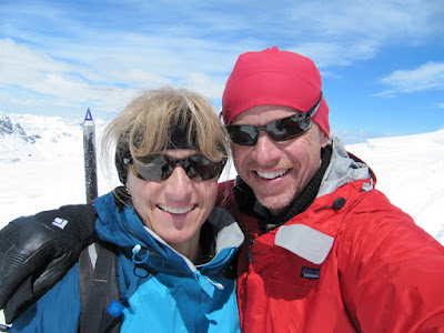
It was truly exciting to be at the top of a mountain that you wanted to climb for a long time. I choked back the lump in my throat and checked out our surroundings. To the south we could see Mts. St. Helens, Adams, Hood, and Bachelor; to the north Baker and Olympus were clear, but Seattle and everything below these peaks was covered from our view with the Pacific Ocean’s motherly blanket of clouds.

We conversed with other climbers; a fellow from Germany took our group pictures. Bob even heard a conversation a fellow in his early 20s was having with his mom on his cellular phone. After telling her he was on the summit of Rainier, Bob heard him tell his mom, “No mom, this is a pretty big mountain; I won’t be home for supper tonight.” We took photos, lots of them, we signed the register (I left my Portage golf tee in the register box), and we crossed the crater to begin our descent to Muir.

It was 11:00 a.m., it was very warm, and from what, apparently, only I had read, we were supposed to back in camp already. The dangerous part of our climb hadn’t occurred yet. We started down.

It was bright, sunny, and very warm. The snow balled under our crampons with each step we took and caused us all to lose our footing and descend in a semislide-step fashion. I noticed at times that my steps landed on very thin patches of glacier that looked like they would break any second, and I pointed them out to Bob behind me.

We had to stop often on our way down so Shane, our leader, could get on his hands and knees and gently probe with his ax to test the integrity of the crossings we’d carefreely plodded over just a few hours before. Seemingly oblivious to the hazards, a couple rope teams loped/ran past us. It seemed inappropriate to go off trail and descend as they were, with the risk of falling into a hidden crevasse at any moment, but they looked like they had a strategy and experience. Their method did not seem to interest any of our team, but their haste caught our attention.

We reached the Ingraham Headwall (which wasn’t the way we planned to come down, but we had missed our turn) at approximately noon. It is a very beautiful but deadly place. You could clearly see the avalanche and rockfall runouts from the headwall, and you could also see that our trail was going to go through them and meander next to them the entire way down. We heard the rumbling of the moving glacier and saw and heard the terror of rockfall, against the peaceful melting of the snow and ice into hidden glacial streams. You could also feel your personal anxiety rise. This was the real thing.

In hindsight, (aside from me sharing the information about leaving early that I had read in the shelter) we should have had a quick group meeting before we entered the headwall area. The conversation should have been very pointed, “See that teeny, tiny spot, way over there? We don’t stop moving through this section until we get there, and we move fast.”

If you’ve ever read Into Thin Air, or other similar stories, you ask yourself, how did those people get in that situation?…if I were there I would have (fill in the blank). I’ve thought the same, but in reality something very different happens. We stopped three times through this section where objective hazards (snow, ice, and rockfall, and opening crevasses) were in charge. I never knew why we were stopping, but I had no interest in it. I wanted to tell our team, “Let’s pass everyone and get out of here.” I felt, and heard, the same anxiety in others, while I think a few team members had no true idea what a high-risk situation we were in. But in mountaineering the unspoken rules are: we are a team, we have a leader, we follow, we do not ditch the same people we hope will pull our butts out of a crevasse because we did not agree with their pace or the number of stops they make. At the same time, I am in the middle of our rope, and having a running conversation in my head, “What am I going to do if Todd (in front) runs in a different direction than Bob (in back) when this slides?” I could just see myself trapped and suspended in the middle of the path of the slide like a pendant on a necklace. But other than some glacier rumblings and another rockfall event (well away from where we were), we got through to high camp without mishap.

We now approached the crevasses we had jumped over in the dark. They were pretty much the same width, but the snow was much softer and you could see how deep they were. So we jumped with more conviction, axes at the ready, and it was only the last person in our party who broke through the landing that all of us noticed when we jumped was thin. He was prepared and had enough velocity in his jump to keep himself from becoming a crevasse rescue. So, on we went…to the bridge.

It was an 8-ft aluminum ladder with two 1 x 4”s laid over the rungs and all lashed together with webbing. There was a fixed line parallel to it that had functioned as a hand rail, of sorts, that morning. The ladder crossed a crevasse with no bottom. It had been a “never mind” to cross in the dark, but it sure looked different now. The fixed line was no longer secure and not an option to use. Axe still at the ready, my first step on the ladder was a slip, as the snow had balled under my crampons and afforded no footing. I quickly leapt backwards and off the ladder to clear my crampons and try again. The second attempt went better, but unlike earlier that morning, the warm temperatures and the wet wood grabbed the crampons on every step. It was an exciting few steps and I was across, and then so was Bob, and then so was the rest of our party.

I finally breathed.

We returned to Muir where everyone napped, except Bob, who busied himself with putting away gear and cooking. At sunset the winds, of which Rainier is so infamous, picked up and while Bob slept through it all I was pelted with the side of the tent all night.

Before sunrise the wind grew even stronger. Our tent was flapping on both of us and I tried to wake Bob once with my concerns. It wasn’t until the pole snapped and the tent collapsed on us that I fully got his attention. He went outside to check out the situation, but it became clear our only option was to take down the tent and retreat to Rainier’s winter shelter. As we were breaking camp we saw a tent, of a party gone on a summit attempt, blow clear off the mountain. They were not going to be happy when they got back.

Getting to the shelter was no easy task for me. The shelter was only 50 ft away, but in high winds, carrying gear, I literally had to hold on to rocks I passed just to stay upright. Quickly, our whole group tore down camp and became shelter refugees.

We began the second part of our descent in the same high winds, but approximately 1,000 ft lower the winds subsided. Bob skied down the Muir snowfield (rugged as it was) and I tried to glissade, but the snow was too soft and warm. I got going a couple times, but eventually just had to stand back up and trudge. After Bob reached the end of the snowfield he actually climbed back up 1,000 ft to take my pack down, and then he climbed the 1,000 ft again just to ski unencumbered. We completed the hike, down the thousands of stairs (I tried to count them in ’96), and the paved trail, back to the parking lot.

After packing the vehicles, cleaning up, a beer in the bar, and T-shirt shopping, the rest of our group left and Bob and I played “tourists” the rest of the afternoon, watching the Rainier movie, strolling through the exhibits, and looking at the mountain through the periscope in the observation building. I think we really had the full experience, and yes, we’d do it again.