Showing posts with label Idaho. Show all posts

Monday, April 28, 2014

Dickey Peak 11,145 ft
High point: Pahsimeroi Mountain Range, Idaho

Dickey Peak
Dickey Peak has been on my list for several years. It’s accessibility from Highway 93 and short, steep approach has been appealing. I also knew it had back country ski possibilities and was looking for Lost River options for Steve. An excellent weather window was forecast for Easter weekend, 2014, so we set our sights on Easter Sunday and headed out from Pocatello a little before 5 a.m.  Driving through Mackay, we immediately noticed the snow was coming off the south and western aspects of the Lost River peaks quickly. As we turned off the road to Arentson Gulch and were able to evaluate our west/northwest ridge approach, it was immediately obvious that there would be no “skinning up” for Steve. Scattered snow patches along our approach were going to mean a few wardrobe/gear changes along the way.

The Pashimeroi Mountains
We parked off the road at 7,459 feet, which we later learned would be a good spot. We started out about 8.15 a.m. The dry land section proceeded quickly and then we were in the lower level snowfields. We were able to make our way all the way through this section with the rare, knee to crotch-deep post hole.  The wind was light and the temperature comfortable as we moved from the continuous snow field to pick our way thought the scree field and snow patches of the steepest section to the upper ridge. 

At about 10,680 feet is where we chose crampons and axes to proceed to the summit. The snow was quite good but on the warm side in places. It could have been kick stepped for the most part, but it was faster not to. The wind stayed light and calm and it was deliciously silent, except for our movements. We were at the summit around 2.30 p.m., which is exceptionally slow (totally me there) and included gear changes and adjustments,. With no wind, perfect temps, and silence, it was so pleasant….nothing was threatening and other than knowing there would be warm(er) snow to deal with down low, no real reason to rush…it truly was a Sunday stroll.


Splattski!
The summit views were stunning, as they are in spring: crisp blue sky, bright white snow, and dark terrain features, punctuated with greens and browns as far as the eye could see. At the summit we looked at our descent options. There was a number of glissade options, but most of them involved a long traverse across Dickey’s base to return to the car. So we headed back toward our original glissade option that paralleled our ascent. As we set up to glissade our biggest concern was snow depth. If the snow was thin, we’d either have to plunge step down or go back to the ridge and take the screeway. Steve went first. Yea! It was perfect, so perfect in fact that I started sliding before I had my axe positioned.  Millisecond correction later and it was everything I (we) could do to not just slide all the way down the gully. What fun! 

We then hiked over rocks back to the lower snowfield and donned snowshoes for the lesser-fun section. The snow trolls had great fun placing random (post) holes for our pleasure and their entertainment. It wasn't horrible, but it might have made the top five. Back on dry land we headed over to the road to find it had turned into a river. Good thing we hadn't taken it farther up. Soon, we were back at the car, beer, chips, sandals and smiles.  On Easter Sunday, I am grateful to still be on mountain tops in exquisite weather! For more photos of this Idaho classic click here!    


4.6 mi (round trip)
3,832 ft (Garmin) gain
Total time: 10 hours (if you're not lollygagging you can knock this off much, much faster)
Weather: clear, below freezing (start) ~ 45 degrees (high) on mountain, no wind

Sunday, August 7, 2011

#111 Bald Mountain


One of the stellar views from hiking Baldy

Bald Mountain Trail
I must have had a pretty stupefied look on my face when she asked, “Margo, do you want to do a hike up on Baldy (i.e., Bald Mountain) with me in the morning”?  Not hours before I had just returned from my solo ascent of Grays Peak in the Pioneer Mountain Range of Idaho. Don’t get me wrong, I’m all up for mountains...the number in the title attests to that fact. And Grays was a respectable near 4,000 ft gain over 7 miles, so I am no slouch. But, frankly, I am of a certain age, where any summit is something to celebrate…just after a few days, not hours, of recovery. So two in a row...ahhhh, I don't know. “We don’t have to go to the top, we’ll just go to the gondola and ride down,” she added. “Well, how long will it take?” I asked. “About 2 hours,” she stated. Well, I don’t have any blisters, no cuts, no injuries from Grays…just really, really sore muscles. Okay, well this might help with recovery. “Ok, sure.”  So at 8:00 a.m. we are off to Baldy or Sun Valley Ski Area, as most folks know it, to head off on a 2.5 mile hike of less than 1.5K vertical. According to SummitPost,

"Bald Mountain...is home not only to North America's first ski resort, but also includes exciting hiking terrain along with unbelievable scenery."
I've been skiing here for years, but really hadn't considering hiking it before. So we are off on our beautiful, leisurely hike, and then something happens to me.  
Carol leads
When we reach the “decision” point, it’s only a mere 2.5 more miles to the top…3,000 ft vertical total. And I can’t help myself…how can I be this close and not go to the summit? “I think we should go to the summit,” I announce. Well alright then. And we continue on. Past wildflowers, ski towers, memorials to loved ones (really...it's a great idea), and beautiful healthy trees.  We climb gently ever higher and make the summit 10 minutes ahead of pace.   
An example view.


But then I notice...we're at the "ski" top...not the summit. "I need to keep going, I will only be a few minutes." Neither Carol nor I had brought anything other than water. After all, we were hiking for 2 hours...that's it. "I really need to get something to eat, and I've been to the top oodles of times," the former Sun Valley ski patroller says. "Absolutely." So we decide that she will go down and I will go up and we'll rendezvous for coffee at the lodge. 

Splattski
So I head up a fraction of a mile and a few feet more. From the top where there is an old lookout, I get views of yesterday's peaks from the west and can see my yesterday, Grays Peak, summit.  I photograph a few peaks of possible future interest and head down.

The Pioneers famous threesome
So this is the best part. If you hike up, you can ride down for free. First the chair lift and then the gondola. It was great. No stress on the knees...wonderful!! ...And it still counts as a peak. For now, I have been down numerous times, strapped to boards, and up the mountain once. It counts. Yeh, and it's all good.

No GPS, no stats. It was only supposed to be a little hike...What I do know is that turned out to be 5 miles, 3,000 ft, another bagged peak, and a fun time with one of my favorite friends. What an awesome weekend!!    
If you haven't considered it before, add hiking (or mountain biking) on Bald Mountain and a latte at the lodge to your bucket list.  
Chairlift Down
 
Gondola Down


Peak #110 Grays Peak, Solo #2


Grays Peak from 9200ish feet.
I have kept this peak at the top of my list for a solo outing and this was the weekend to go after it.  From SummitPost, "Grays Peak is a large hulking summit that stands out from the main crest of the Pioneer Mountains like a soar thumb. Although not as high nor rugged as its Pioneer counterparts, Grays Peak is still an attractive cone-shaped peak that is especially beautiful in winter."

I had checked into Grays in 2009 after my first solo. The folks on the Idaho Summits board recommended it for its proximity to the road (I drive a Nissan...not an off-road friendly vehicle), straightforward approach, and at class II/III, depending on conditions, was within my abilities, especially as a solo.
"Hal" at the trail head.

I decided to take the west ridge approach both ways, thinking it was easiest but noted that it would be relatively easy to bushwhack down to the Federal Gulch trail should I need to get off of the ridge. I took my GPS, with an estimated approach route, and unlike my first solo, a hard copy topo and a trip report.

I left Friday afternoon to stay with friends in Hailey and left at 6:45 a.m. to reach the trail head for a reasonably early start. According to my beta, it would be 5 miles and 4500 feet.
Heading to the high point at 9200ish ft.

When I reached the summit in almost exactly 4 hours, I was pretty stoked and in a little disbelief. After all, I got wrapped around a couple rock outcrops at lower elevations that ate up some time and I took a number of micro-breaks (stop for a moment until your breathing stops racing) when I was climbing above timberline.
View from 9200 ft
So, my ascent time seemed a little good to be true, but overall I felt pretty good, so I guess it was possible.

While on the summit I noticed weather building to the west and heading my way. Nothing too immediate, but sure enough to get a move on. So after the requisite snack break, 360 photos, video and Splattski, I was off.

Splattski!!
I made the decision because of the weather that staying on the ridge may not be a good idea. When I spotted the lower trail I bushwhacked a rib down toward it and followed the trail until it tied into the Federal Gulch trail.

Feetski!!
Once on the lower trail, I took my time to "smell the roses" as it were, or in my case, photograph butterflies. Where the trail came near the stream it was flooded so I spent some time trail- and vegetation-clump hoping to stay dry. The vegetation is some sections was SOOO tall that I couldn't see the trail in front of me, or under my feet, so I proceeded by "feet feel." A few stream crossings later, I was back at the car and then the shower started...perfect timing.

Bushwacking to the Federal Gulch Trail.
It took me 6 hours for the entire trip, including breaks. According to my GPS, total elevation was 3760 ft, and 7 miles long. Even though it wasn't as much elevation as I expected, I moved along quite well considering. I saw NO ONE, I heard nothing other than the sounds of nature. I left no trace. Thank you Sawtooth National Forest, Ketchum Ranger District for the non-motorized wilderness experience and for accurate signage. Thank you IdahoSummits Board, as always, for your knowledge and encouragement and friendship. Thank you family and friends for your support.
You can't buy more nature...only preserve, protect and enjoy it!
On may way out I stopped by the Hyndman Trail head just to, you know, look around...like at Cobb and other ideas.
:-)

My Route.


Monday, October 19, 2009

No. 67, Deep Creek Peak

I wanted to go somewhere close to Pocatello, with a little less vertical than the 4,000+/trip I've done in recent weekends. Deep Creek Peak is the highpoint of the Deep Creek mountains in southeast Idaho that lie between Arbon and Rockland Valleys.

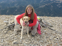
I planned on going solo but asked Margie, who's knee deep in sanding and staining her deck, to go. Putting added pressure on her, I mentioned that the peak was Maka (her dog) friendly. It wasn't until Saturday night that I found out that she had picked up the pace, finished her deck, and that I'd be having company.

Being overconfident in the peak's accessibility and straightforward route (per Dan's trip report), I opted not to download a map to the gps or print out a trip report, but I did bring Tom Lopez's book, with plans to use it for driving directions. Margie said she had been on the road and in that area before, so that was good enough for me. The route is 5 miles roundtrip, with a summit elevation of 8,748 ft and 2,000 vertical to get there, similar to our local Scout Mountain and Bonneville Peak, so we left Pocatello at 7:00 a.m. with expectations to be back by early afternoon.

After leaving I-86, we had the two-lane highway south through Arbon Valley to ourselves. Dawn was trying to break through the clouds when all the sudden, there he was, in the middle of our lane, a buck whose back was higher than the hood of her SUV. I didn't even have a chance to utter anything, I just looked over at Margie to see if she was seeing him, and her audible gasp answered my question. I had no more than a split second to look back at him to see if impact was inevitable. Margie was just processing her evasive action, when he decided he should move, quick. We passed him without getting a chance to swerve and within an inch of his rear. Margie could see his hair move in the swish of our passing.

Well it's a shame her heart rate monitor wasn't turned on, because I'm sure it would have belied her calm exterior. After some conversation about how much it would have sucked to fix her front end a second time, within months of the first time, we continued watching for his friends and looking for our turnoff.

Soon we were on Knox Canyon road, heading to the start of our ascent route. On the way we saw hunters with horses, hunters with atvs, and hunters with no plans to be more than 100 yards from their rigs for any reason (i.e., illegal road hunting, lovely). The biggest disappointment to me was to see how littered and dirty looking everything was within viewing distance of the road. I am convinced there are two classes of hunters. One class with, and one without. At least in this area, there seem to be a lot of hunters in that latter class.

Tom's book indicated that we were looking for an "intersection" of sorts on a "crest" (one way) or (traveling from the opposite direction)a "pass." And pass we did...the pass, that is (p.s. consistent terminology is really important, it's either a pass or a crest from either direction...yes I would love a climbing guide editing gig...email me). We understood we'd be doing a west approach on the peak, so we figured we needed to descend the road some more to reach said intersection. So without looking in the rear-view mirror, we kept going and traveled all the way to the north-south highway in the next (Rockland) valley, and the sign there told us, that we were on the Big Canyon road. Yep, just east-wested the entire range.

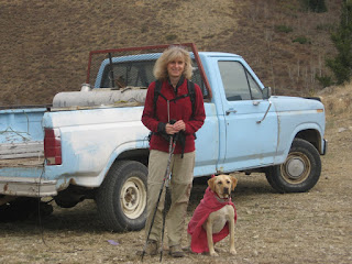
The error was obvious and we set the trip-o-meter to backtrack the 9 or so miles (per Tom' s book) where we suspected we should be. And, at about 9 miles, we were at the blue pickup hunter truck we saw on the way down. Must be here. We pulled in next to the truck.

We piled out, donned gear, and tried to make apparel decisions for the not-so-good-of-a-weather day we didn't expect but we were clearly going to get. Donning gear concluded with red shirts (hunter protection) all around...Maka included.

[I don't purposely try to hike or not hike during hunting season. It is something I don't really pay much attention to as in, I thought back at my the house, "Hum...there may be hunters out, hum, but i have no red or orange, hum...this is pretty much a ridge hike and I have a bright yellow backpack. Good enough." ]

So 
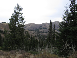
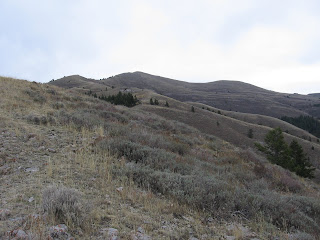
without looking in the rear-view mirror (i.e., behind us), we start off, 9:30, by crossing the road and immediately hiking up a steep hill, with no faint jeep trail noticeable (something I remember reading in a trip report somewhere). Then we're quickly in a very brushy section, sidehilling, with our first views of one of the multiple little peaks we'd go up and over before we would reach the summit. But something was bothering me. I kept looking ahead trying to see the ridge route that would be the majority of our climb and was seeing nothing other than more brush and heavy forest. Just not what I expected. I suggested we move from the sidehill to the top of the ridge above us and get a better look around. By then, we actually turned around and saw the peak we were supposed to be climbing, across the gully, the start visible less than 1/2 mile further up the road. So, down we went, and now with a 0.6-mi hill warm up under our boots and paws, we piled back in the car, moved it up the road, piled out and tried again.

It was at this point that the jeep trail was more than noticeable and as we continued, the route manifested as Dan describes in his trip report, "The hike starts out of a brushy, semi-forested ridge, that provides a challenge as it roller coasters up to the peak itself. Once on the mountain, the ridge becomes bare and a very easy terrain to hike." Spot on, Dan.

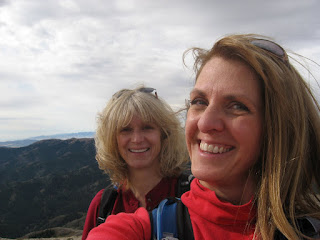
We discovered that Maka loves, among other things, tracking the trail, and she lead us the whole way. She was a little confused around a rock outcrop where numerous game trails exist. At that point we had to keep directing her upwards. Finally in the all too common blasting southeast Idaho winds, and significantly cooler temperatures than anticipated, we summited with plans to tag-off, take photos, and descend to a lunch spot that was out of the wind.

Even on this overcast day, there was at least 100 miles visibility. Bannock Peak (on the Fort Hall Indian Reservation) is a distinctive pyramidal shape, to the north, and this was my closest look at it from a mountaineering standpoint. Non-Native Americans are not allowed on the peak without permission from the Tribal Council, which I have learned through two attempts isn't (probably ever) granted. Mt. Harrison, and Cache and Independence Peaks were visible on the southwest. A dusting of snow was visible on Black Peak and Black Pine Peak to the south, which we'd summited a couple weeks before. The Lemhis were still snowcapped, Big Southern Butte had lost its snow, and the sun was shining on the Pioneers to the northwest.

The ascent was uneventful, just windy. On the descent, within about 20 minutes of the car, my left hiking pole collapsed sending me to the ground in a very hard side ankle roll. So i gimped a bit on the way out with new appreciation for "Margo tight," when adjusting the poles, not being tight enough. There were lots of shots taken by hunters but not at or near us. The only downside, if any, was the lost time caused by us not finding the trail head on first try (because I didn't download any coordinates/maps, lesson learned), and that sour melon poweraid is REALLLLY terrible.


It took us 5 minutes longer to complete the route than Dan and Zach. Including summit time and lunch...so we were quite pleased. We do agree with Dan that this is a good early season hike/conditioner once the road is open. So keep this in mind for next spring.
More photos here.

Sunday, September 20, 2009

New Peaks (Nos. 63 and 64) and Nano Panorama

Today Margie, Maka and I climbed Black Pine Peak and Black Peak out of the Black Pine Mountains in southeast Idaho. More precisely...out of the Malta, Idaho, area. It was really, really windy and sunny. Probably 45-55 with chill. I was very close to digging out my winter hat and gloves. Had three light layers on top for the last 1/4 of the mountain, which i wasn't expecting. Nice workout though. The views weren't crystal clear with the wind and haze and particles about, but i got to try the video function on my new nano. It was soooooooo windy i thought it would fly outta my hand so I didn't fuss with it too much. This is the best video of the bunch. I'm sure the next generations will have even better functioning...that will be a quandry...i just got this one. If they can nail video AND have photo capability and still stay this small, it could replace a lot of cameras. Talk about ultralight.

I'm behind posting my summer summits. But i don't have the discipline to write the ones i am behind on first...I want to see how well the ipod video works because i'm just fascinated with the upgrades since my first generation ipod. By the way, between the gps, the camera, and the ipod, post-trip analysis/activities are begining to take longer than my pre-trip activities.